Von Kklara hochgeladene Dateien
Aus Klimawandel
Diese Spezialseite listet alle hochgeladenen Dateien auf.
| Datum | Name | Vorschaubild | Größe | Beschreibung | Versionen |
|---|---|---|---|---|---|
| 13:05, 29. Sep. 2020 | Wildfires over Oregon.jpg (Datei) |  |
4,77 MB | Waldbrände in Oregon, Satellitenbild vom 9. September 2020, rechte Abbildung mit kurzwelliger Infrarotstrahlung erzeugt. ==Lizenzhinweis== {| style="border:1px solid #8888aa; background-color:#f7f8ff;padding:5px;font-size:95%;" | Quelle: Copernicus Se… | 1 |
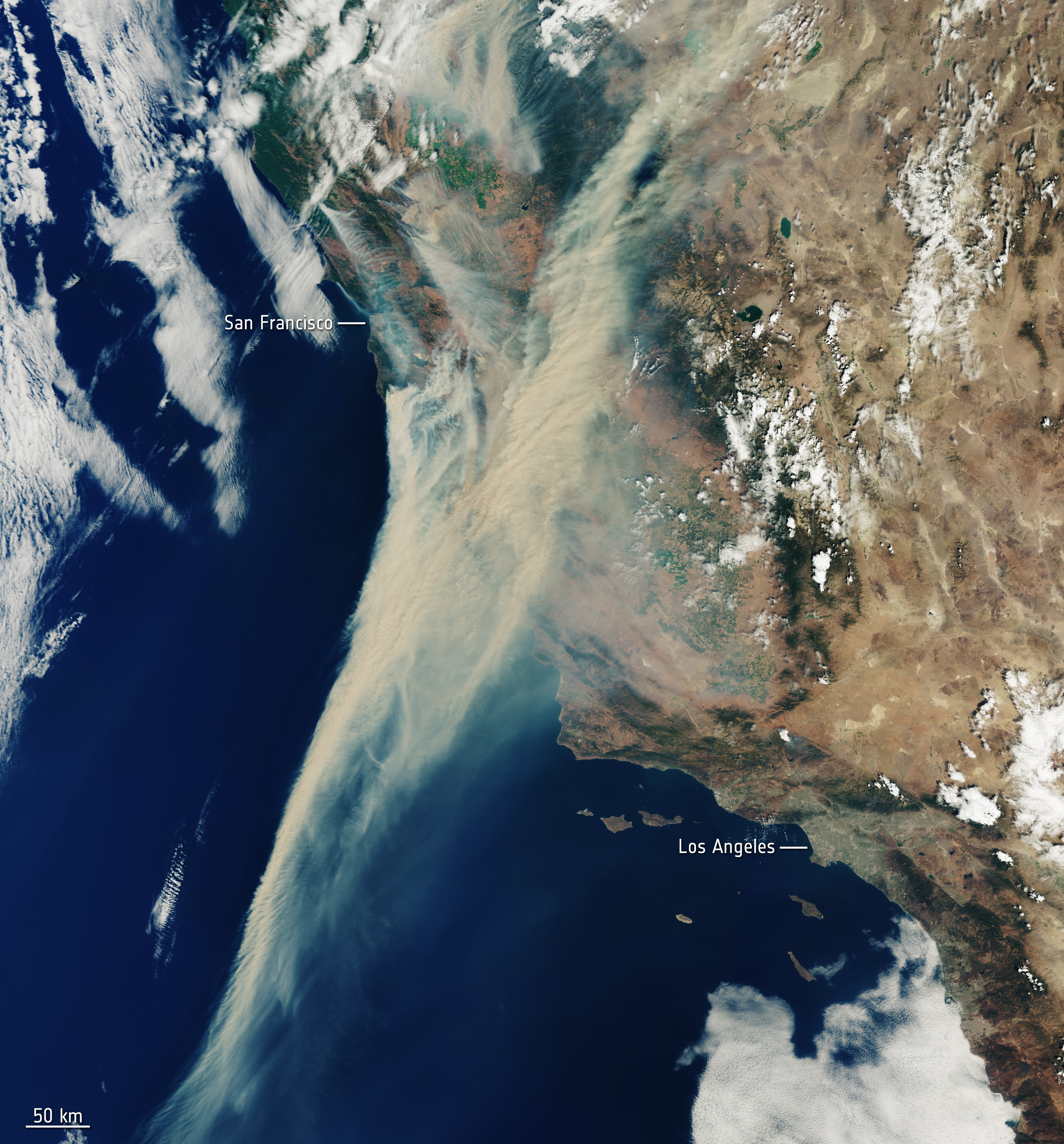
| 12:55, 29. Sep. 2020 | California on fireJpeg.jpeg (Datei) |  |
2,56 MB | Waldbrände in Kalifornien, Satellitenbild vom 19. August 2020 ==Lizenzhinweis== {| style="border:1px solid #8888aa; background-color:#f7f8ff;padding:5px;font-size:95%;" | Quelle: Copernicus Sentinel data (2020): [https://www.esa.int/ESA_Multimedia/Ima… | 1 |
| 12:41, 29. Sep. 2020 | Carbon monoxide from west coast fires.jpg (Datei) |  |
1,62 MB | Kohlenstoffemissionen durch Waldbrände an der US-Westküste, 01.08. bis 14.09.2020 ==Lizenzhinweis== {| style="border:1px solid #8888aa; background-color:#f7f8ff;padding:5px;font-size:95%;" | Quelle: Copernicus Sentinel data (2020): [https://www.esa.i… | 1 |
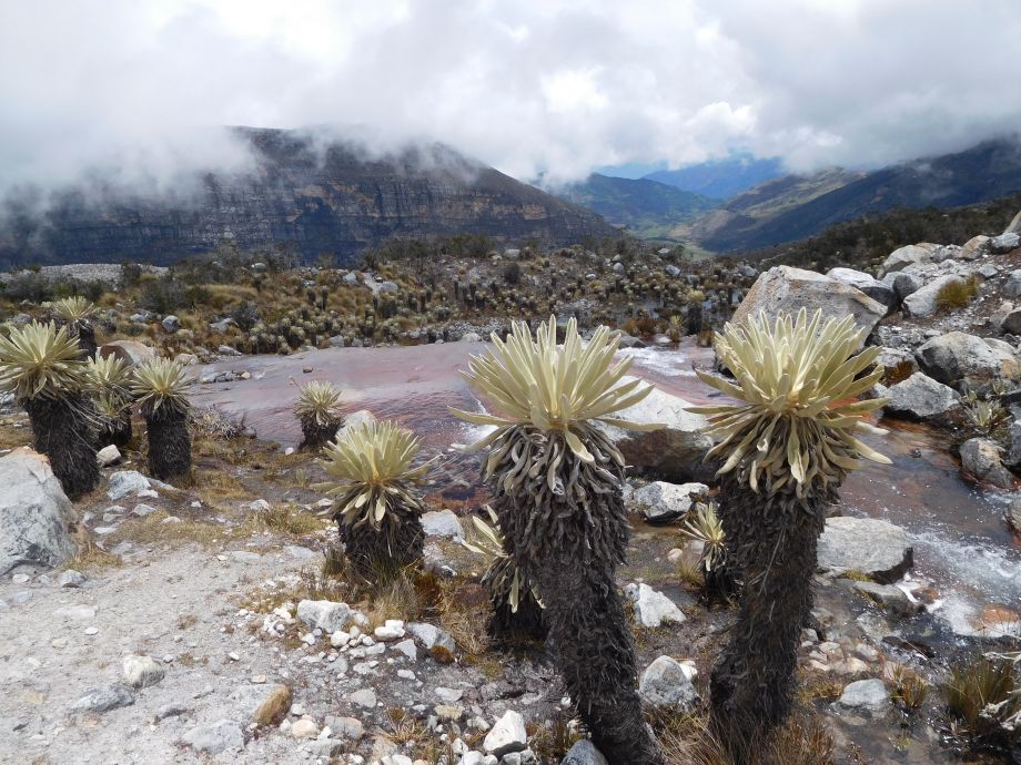
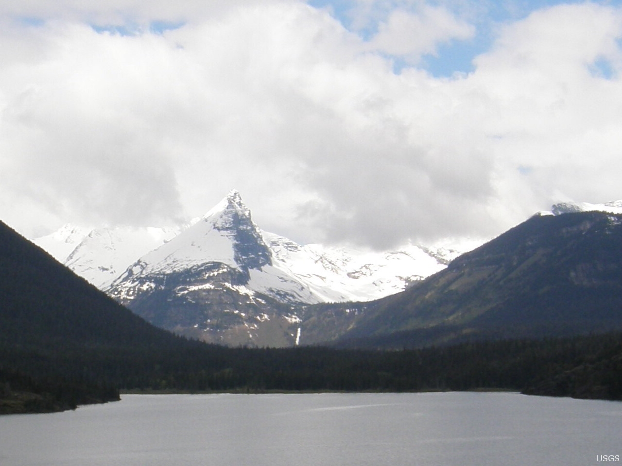
| 18:42, 27. Feb. 2020 | Paramo sierraNevadaElCocuy.jpg (Datei) |  |
212 KB | Parámo in der Sierra Nevada del Cocuy, Kolumbien 2018. Das andine Sumpfgebiet wird von Gletscherwasser gespeist und speichert dieses unter anderem in der Vegetation. Im Vordergrund die für Parámos typische Pflanze des Freilejón. ==Lizenzhinweis==… | 1 |
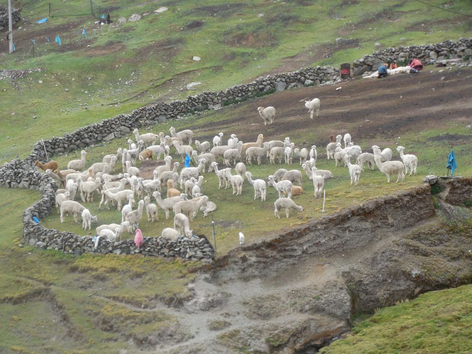
| 18:38, 27. Feb. 2020 | Alpacas peru.jpg (Datei) |  |
203 KB | Viele Familien in den Anden leben von der Zucht von Lamas und Alpakas. Durch die globale Erwärmung fällt der Niederschlag in den hochandinen Gebieten jedoch zunehmend als Regen. Während die Tiere Schnee einfach von ihrem Fell schütteln können, dur… | 1 |
| 17:33, 27. Feb. 2020 | Gletscherrueckzug PNN ElCocuy.JPG (Datei) |  |
273 KB | Gletscherrückgang im kolumbianischen Nationalpark El Cocuy. Durch den Rückzug des Gletscher wird das Geröllfeld freigelegt und die Lagune wächst. Foto von April 2018. ==Lizenzhinweis== {| style="border:1px solid #8888aa; background-color:#f7f8ff;pa… | 2 |
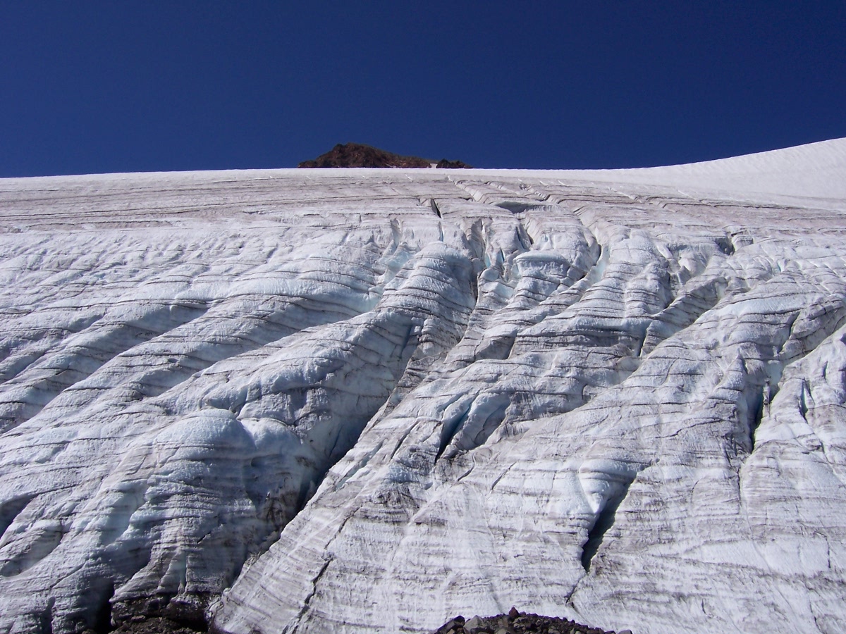
| 16:39, 27. Feb. 2020 | Gletscher pastoruri peru.jpg (Datei) |  |
3,31 MB | Pastoruri-Gletscher in der Cordillera Blanca in Perú, Juni 2018 ==Lizenzhinweis== {| style="border:1px solid #8888aa; background-color:#f7f8ff;padding:5px;font-size:95%;" | Autorin: Klara Kolhoff, Creative Commons Lizenz 3.0 <shtml hash="%%_HTML_&&_… | 1 |
| 17:38, 25. Feb. 2020 | California gis 2018.png (Datei) |  |
119 KB | Jährlich von Feuern betroffene Fläche in Kalifornien nach Regionen und nach Jahreszeiten. ==Lizenzhinweis== {| style="border:1px solid #8888aa; background-color:#f7f8ff;padding:5px;font-size:95%;" | Quelle: Joshua Stevens, NASA Earth Observator [htt… | 1 |
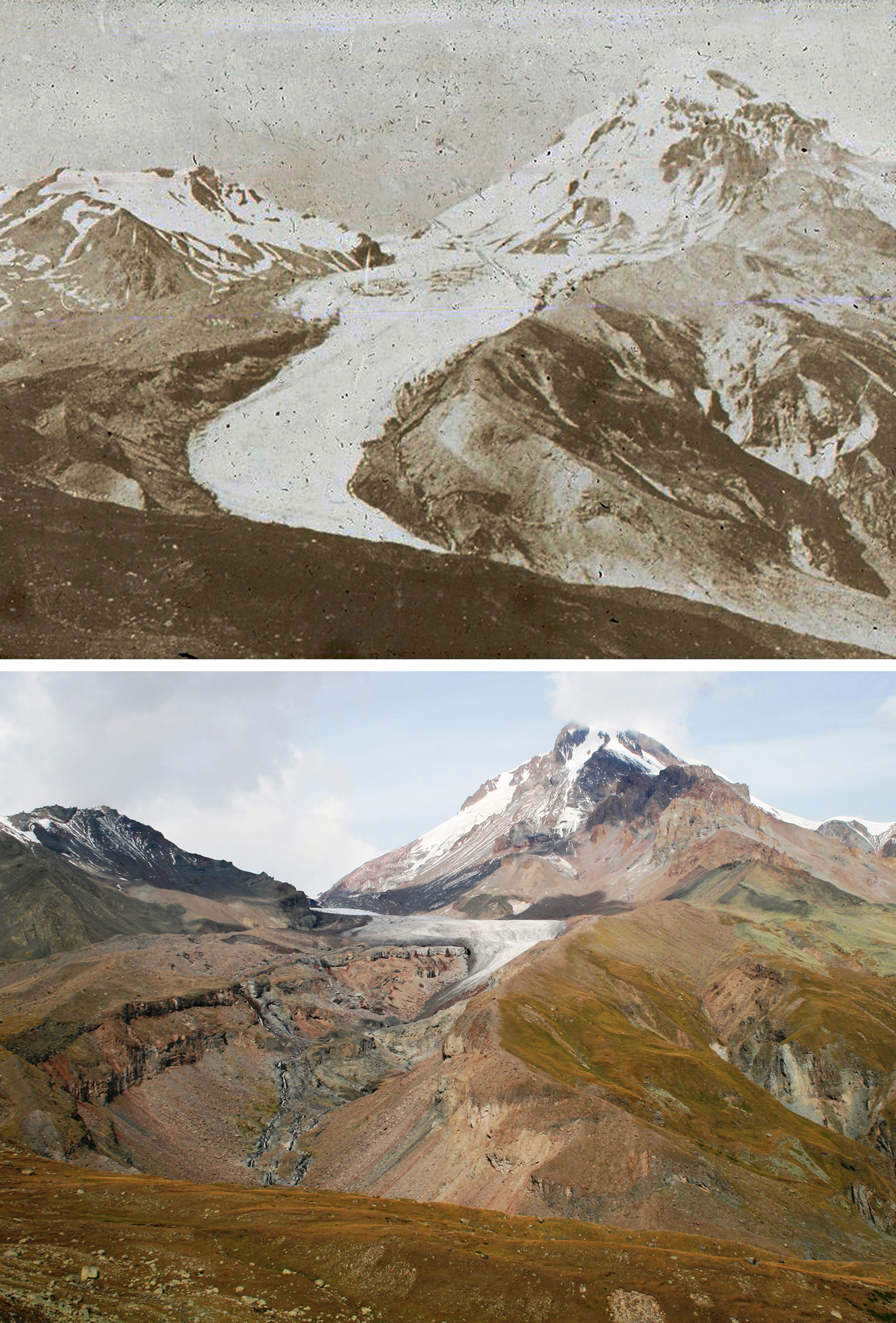
| 16:23, 25. Feb. 2020 | Gergeti glacier1890 2011.jpg (Datei) |  |
1,76 MB | Gergeti-Gletscher in Georgien 1890 und 2011 ==Lizenzhinweis== {| style="border:1px solid #8888aa; background-color:#f7f8ff;padding:5px;font-size:95%;" | Quelle: Levan Tielidze<br> Lizenz: [https://creativecommons.org/licenses/by-sa/3.0/ CC BY SA 3.0] |} | 1 |
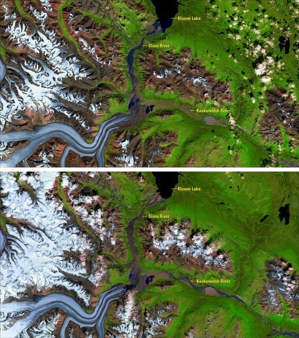
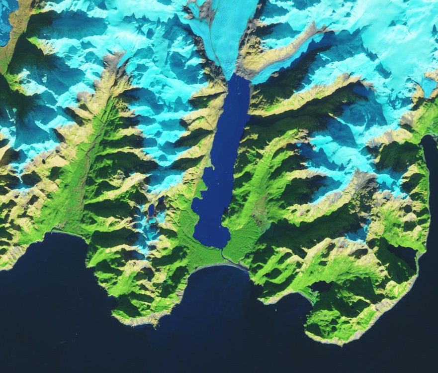
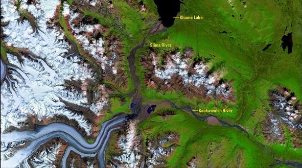
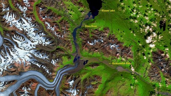
| 17:18, 24. Feb. 2020 | Kaskawulsh-glacier 03 08 15and04 07 16.jpg (Datei) |  |
220 KB | Luftbilder des Kaskawulsh-Gletscher vom 03.08.2015(oben) und vom 04.07.2016(unten). Erkennbar ist, dass sich zwischen den beiden Bildern die Hauptflussrichtung des Schmelzwassers von einem Abfluss in den Slims-River hin zu einem Abfluss in den Kaskawul… | 1 |
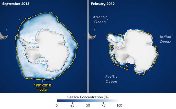
| 15:39, 19. Feb. 2020 | Antarctic nsidc 2019.png (Datei) |  |
186 KB | Antarktisches Meereis im September 2018 und Februar 2019 ==Lizenzhinweis== {| style="border:1px solid #8888aa; background-color:#f7f8ff;padding:5px;font-size:95%;" | Quelle: NASA Earth Observatory: [https://earthobservatory.nasa.gov/world-of-change/sea… | 1 |
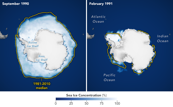
| 15:37, 19. Feb. 2020 | Antarctic nsidc 1991.png (Datei) |  |
189 KB | Antarktisches Meereis im September 1990 und Februar 1991 ==Lizenzhinweis== {| style="border:1px solid #8888aa; background-color:#f7f8ff;padding:5px;font-size:95%;" | Quelle: NASA Earth Observatory: [https://earthobservatory.nasa.gov/world-of-change/sea… | 1 |
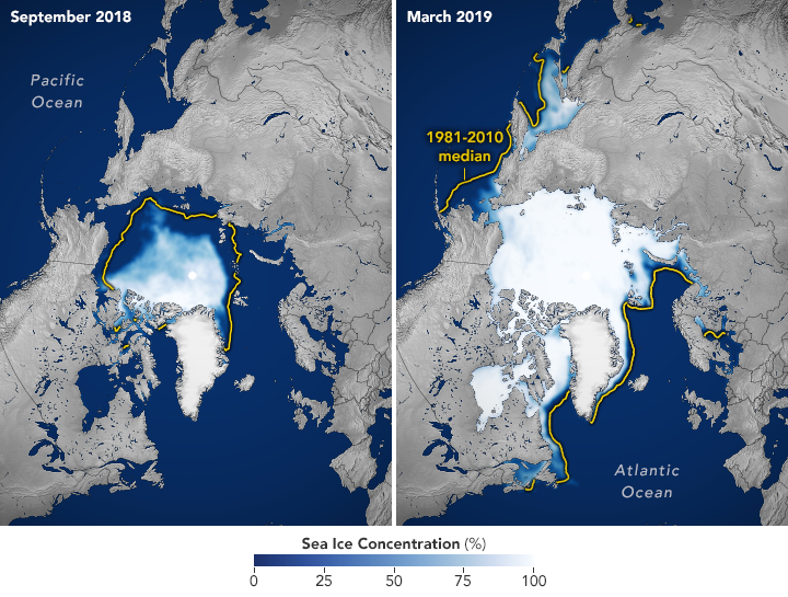
| 15:30, 19. Feb. 2020 | Arctic nsidc 2019.png (Datei) |  |
357 KB | Arktisches Meereis im September 2018 und März 2019 ==Lizenzhinweis== {| style="border:1px solid #8888aa; background-color:#f7f8ff;padding:5px;font-size:95%;" | Quelle: NASA Earth Observatory: [https://earthobservatory.nasa.gov/world-of-change/sea-ice-… | 1 |
| 15:27, 19. Feb. 2020 | Arctic nsidc 1991.png (Datei) |  |
359 KB | Arktisches Meereis im September 1990 und März 1991 ==Lizenzhinweis== {| style="border:1px solid #8888aa; background-color:#f7f8ff;padding:5px;font-size:95%;" | Quelle: NASA Earth Observatory: [https://earthobservatory.nasa.gov/world-of-change/sea-ice-… | 1 |
| 15:13, 19. Feb. 2020 | Columbia glacier 2019.jpg (Datei) |  |
2,89 MB | Columbia Glacier am 21. Juni 2019 ==Lizenzhinweis== {| style="border:1px solid #8888aa; background-color:#f7f8ff;padding:5px;font-size:95%;" | Quelle: NASA Earth Observatory: [https://earthobservatory.nasa.gov/world-of-change/columbia_glacier.php World… | 1 |
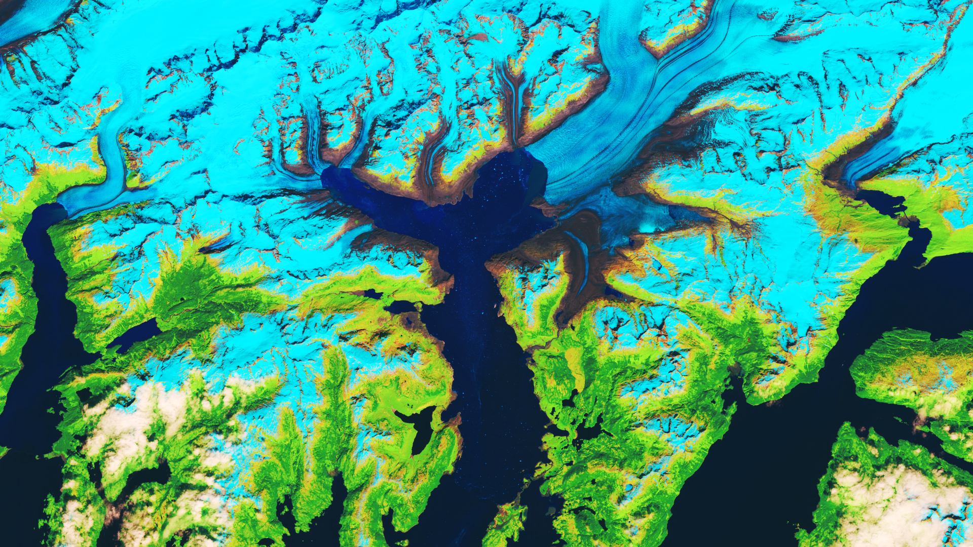
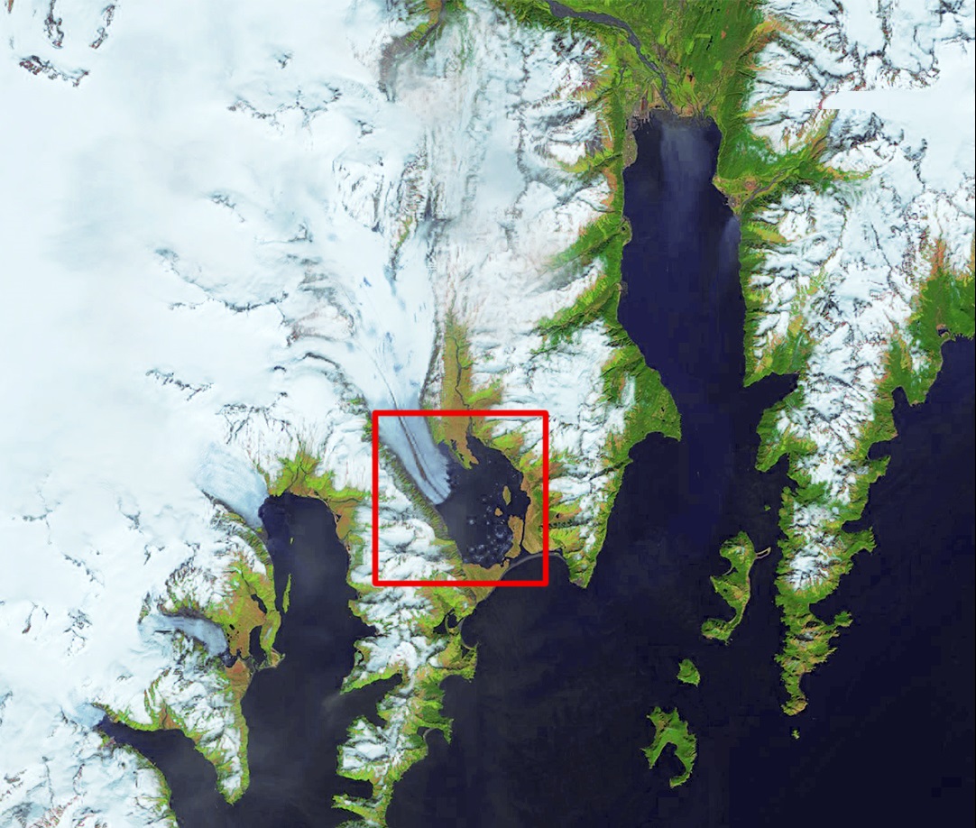
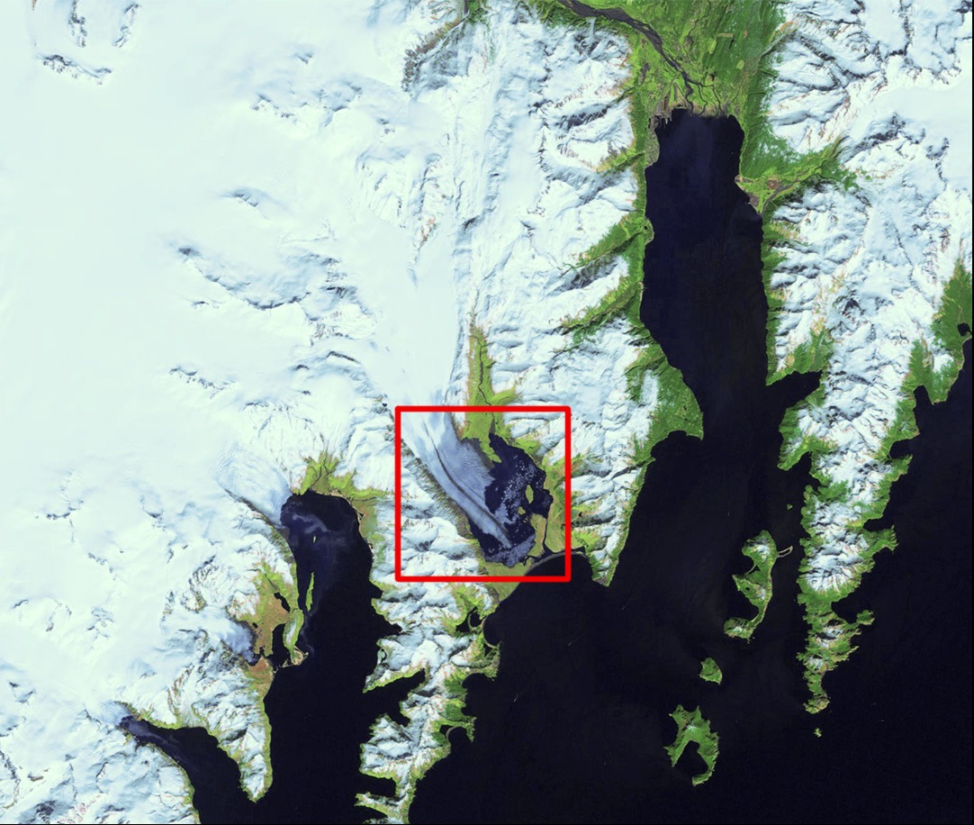
| 16:17, 18. Feb. 2020 | Blick von ISS Alaska.jpg (Datei) |  |
2,45 MB | Blick auf Alaska von der Internationalen Raumstation (ISS) 27. April 2019 ==Lizenzhinweis== {| style="border:1px solid #8888aa; background-color:#f7f8ff;padding:5px;font-size:95%;" | Quelle: NASA Earth Observatory: [https://earthobservatory.nasa.gov/i… | 1 |
| 16:15, 18. Feb. 2020 | NASAexcelsiorglacier bigJohnstoneLake 2018.jpg (Datei) |  |
268 KB | Entstehung des Big Johnstone Lake aus Schmelzwasser des Excelsior-Gletscher 2018 ==Lizenzhinweis== {| style="border:1px solid #8888aa; background-color:#f7f8ff;padding:5px;font-size:95%;" | Quelle: NASA Earth Observatory: [https://earthobservatory.nasa… | 1 |
| 16:12, 18. Feb. 2020 | NASAexcelsiorglacier bigJohnstoneLake 1986.jpg (Datei) |  |
289 KB | Entstehung des Big Johnstone Lake aus Schmelzwasser des Excelsior-Gletscher 1986 ==Lizenzhinweis== {| style="border:1px solid #8888aa; background-color:#f7f8ff;padding:5px;font-size:95%;" | Quelle: NASA Earth Observatory: [https://earthobservatory.nasa… | 1 |
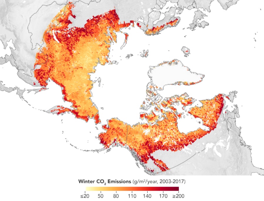
| 15:49, 18. Feb. 2020 | Permafrost kohlenstofffreisetzung nasa eo.jpg (Datei) |  |
162 KB | Permafrostboden als Kohlenstoffdioxidquelle in den Wintermonaten 2003-2017 ==Lizenzhinweis== {| style="border:1px solid #8888aa; background-color:#f7f8ff;padding:5px;font-size:95%;" | Quelle: Joshua Stevens, NASA Earth Observatory: [https://earthobse… | 1 |
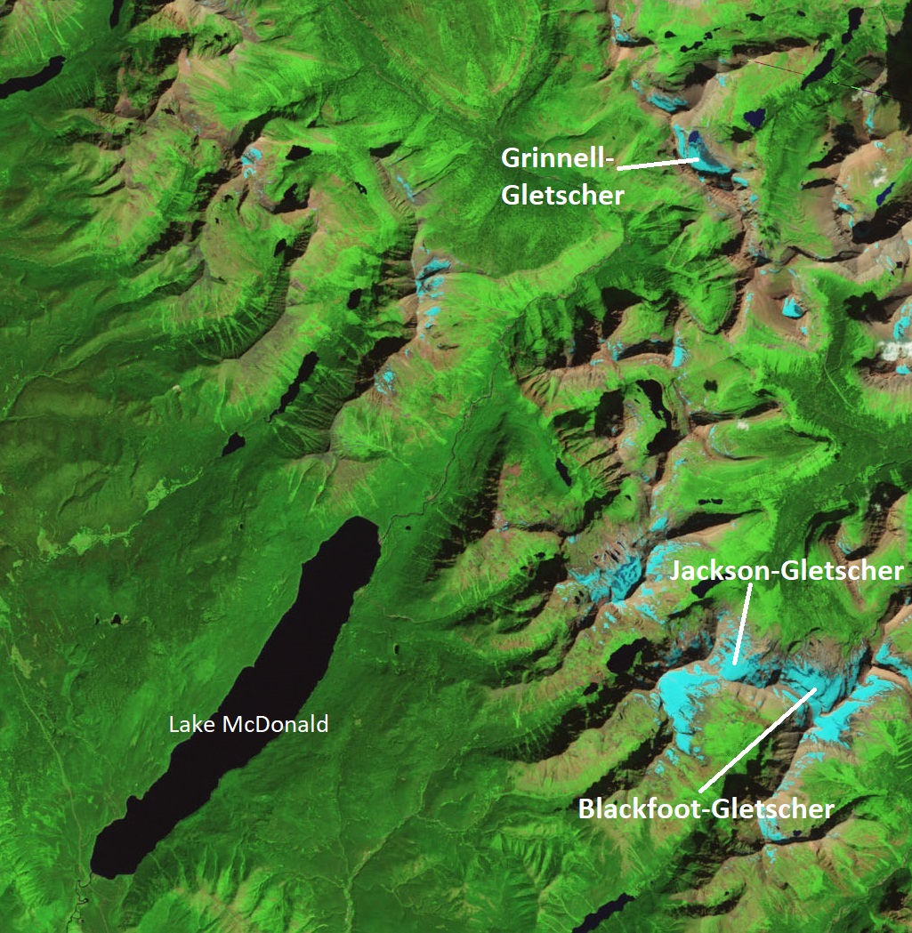
| 13:08, 18. Feb. 2020 | NationalGlacierPark Landsat 2009 beschriftet.jpg (Datei) |  |
481 KB | Luftbild eines Gebietes des Glacier National Park 2009. Grinnell-Gletscher, Jackson-Gletscher und Blackfoot-Gletscher. ==Lizenzhinweis== {| style="border:1px solid #8888aa; background-color:#f7f8ff;padding:5px;font-size:95%;" | Quelle: NASA Earth Obse… | 1 |
| 13:04, 18. Feb. 2020 | NationalGlacierPark Landsat 1984 beschriftet.jpg (Datei) |  |
496 KB | Luftbild eines Gebietes des Glacier National Park 1984. Grinnell-Gletscher, Jackson-Gletscher und Blackfoot-Gletscher ==Lizenzhinweis== {| style="border:1px solid #8888aa; background-color:#f7f8ff;padding:5px;font-size:95%;" | Quelle: NASA Earth Obser… | 1 |
| 12:24, 18. Feb. 2020 | Blackfoot Jackson 2009.jpg (Datei) |  |
619 KB | Blackfoot-Gletscher und Jackson-Gletscher 2. September 2009 ==Lizenzhinweis== {| style="border:1px solid #8888aa; background-color:#f7f8ff;padding:5px;font-size:95%;" | Quelle: Lisa McKeon, USGS: [https://www.usgs.gov/media/images/blackfoot-jackson-20… | 1 |
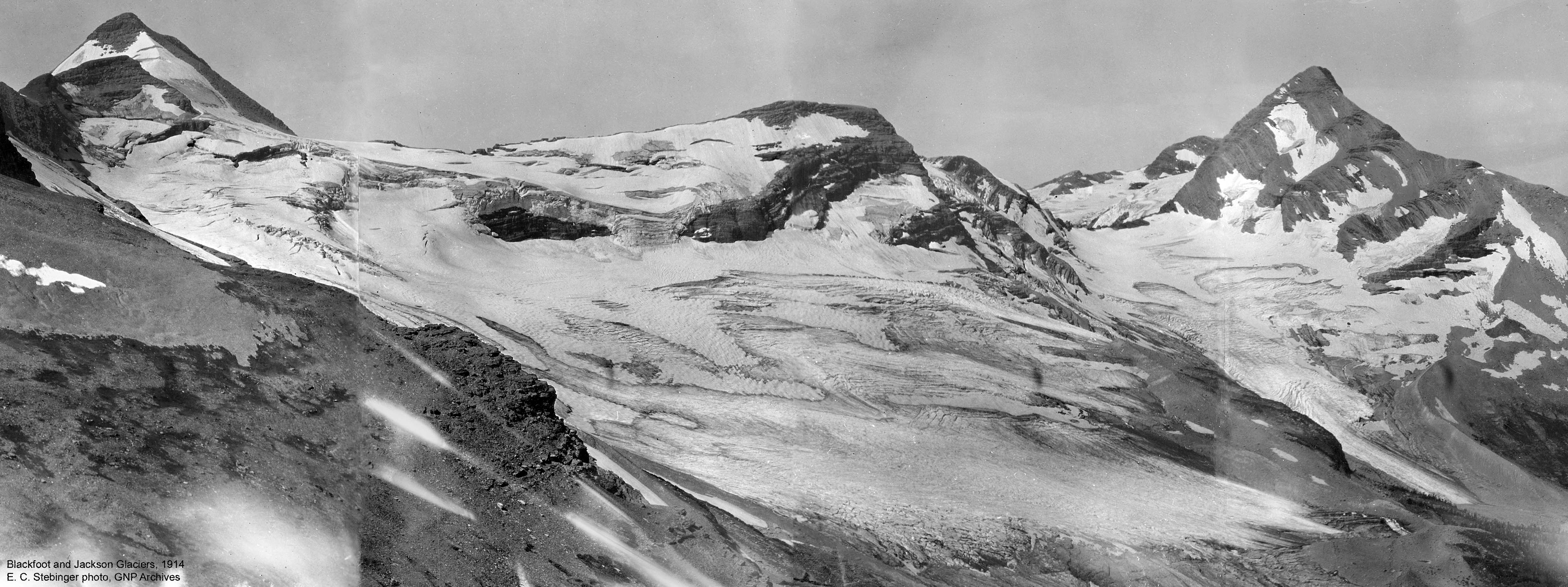
| 12:08, 18. Feb. 2020 | Blackfoot Jackson 1914.jpg (Datei) |  |
970 KB | Blackfoot-Gletscher und Jackson-Gletscher 1914 ==Lizenzhinweis== {| style="border:1px solid #8888aa; background-color:#f7f8ff;padding:5px;font-size:95%;" | Quelle: E. C. Stebninger, Glacier NP: [https://www.usgs.gov/media/images/blackfoot-jackson-1914… | 1 |
| 11:43, 18. Feb. 2020 | 2006 scascade glacier .jpg (Datei) |  |
8,28 MB | South Cascade-Gletscher 2006 ==Lizenzhinweis== {| style="border:1px solid #8888aa; background-color:#f7f8ff;padding:5px;font-size:95%;" | Quelle: USGS: [https://www.usgs.gov/media/images/2006-south-cascade-glacier South Cascade Glacier 2006]<br> Lizen… | 1 |
| 11:38, 18. Feb. 2020 | 1928 scascade glacier.jpg (Datei) |  |
149 KB | South Cascade-Gletscher 1928 ==Lizenzhinweis== {| style="border:1px solid #8888aa; background-color:#f7f8ff;padding:5px;font-size:95%;" | Quelle: USDA, USGS: [https://www.usgs.gov/media/images/1928-south-cascade-glacier South Cascade Glacier 1928]<br>… | 1 |
| 11:04, 18. Feb. 2020 | MuirRiggs-2004.jpg (Datei) |  |
1,95 MB | Muir-Gletscher (nicht mehr im Bildausschnitt) und Riggs-Gletscher (rechts) 2004 ==Lizenzhinweis== {| style="border:1px solid #8888aa; background-color:#f7f8ff;padding:5px;font-size:95%;" | Quelle: Bruce Molnia, USGS: [https://www.usgs.gov/media/images/… | 1 |
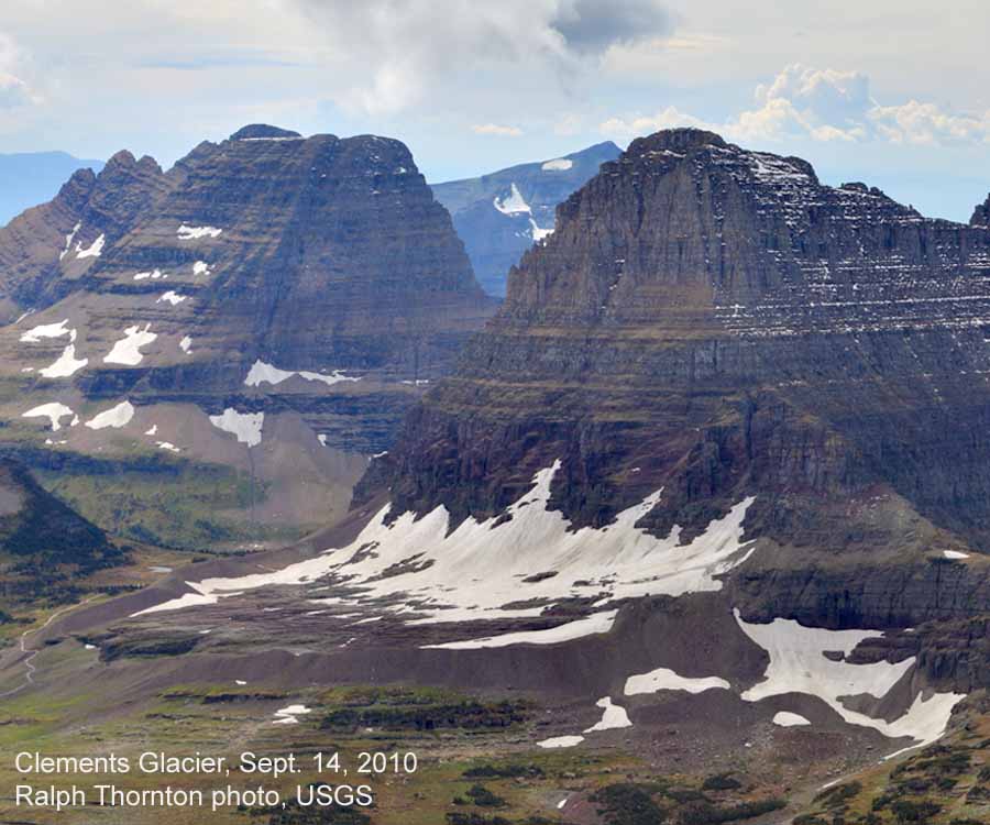
| 16:21, 17. Feb. 2020 | Clements glacier 2010.jpg (Datei) |  |
110 KB | ==Lizenzhinweis== {| style="border:1px solid #8888aa; background-color:#f7f8ff;padding:5px;font-size:95%;" | Quelle: Ralph Thornton, USGS: [https://www.usgs.gov/media/images/clements-2010 Clements Glacier 2010]<br> Lizenz: public domain |} | 1 |
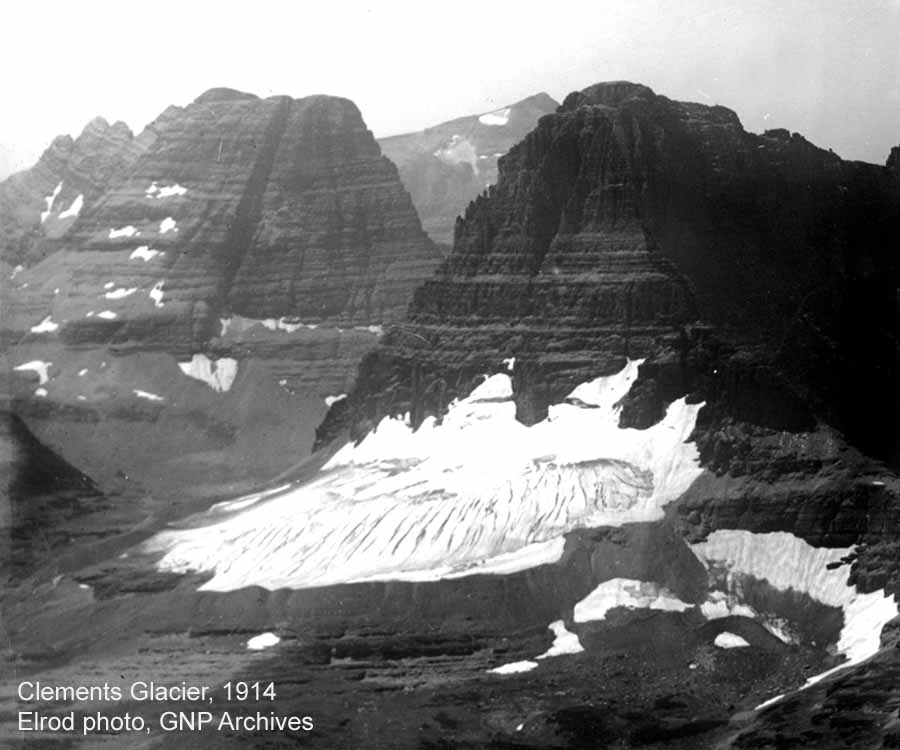
| 16:15, 17. Feb. 2020 | Clements glacier 1914.jpg (Datei) |  |
81 KB | Clements-Gletscher (Montana) 1914 ==Lizenzhinweis== {| style="border:1px solid #8888aa; background-color:#f7f8ff;padding:5px;font-size:95%;" | Quelle: Elrod, Glacier NP, USGS: [https://www.usgs.gov/media/images/clements-1914 Clements Glacier 1914]<br>… | 1 |
| 18:39, 14. Feb. 2020 | Shepard glacier 2005.jpg (Datei) |  |
1,82 MB | Shephard Glacier (Montana) 2005 ==Lizenzhinweis== {| style="border:1px solid #8888aa; background-color:#f7f8ff;padding:5px;font-size:95%;" | Quelle: USGS: [https://www.usgs.gov/media/images/grinnell-glacier-1938 Grinnell Gletscher 1938]<br> Lizenz: p… | 1 |
| 18:37, 14. Feb. 2020 | Shepard glacier 1913.jpg (Datei) |  |
1,73 MB | Shephard-Gletscher (Montana) 1913 Grinnell Glacier 1938 ==Lizenzhinweis== {| style="border:1px solid #8888aa; background-color:#f7f8ff;padding:5px;font-size:95%;" | Quelle: USGS: [https://www.usgs.gov/media/images/shepard-glacier-glacier-national-park… | 1 |
| 18:35, 14. Feb. 2020 | Grinnell glacier 1981.jpg (Datei) |  |
1,28 MB | Grinnell Glacier 1981 ==Lizenzhinweis== {| style="border:1px solid #8888aa; background-color:#f7f8ff;padding:5px;font-size:95%;" | Quelle: USGS: [https://www.usgs.gov/media/images/grinnell-glacier-mount-gould-1981 Grinnell Gletscher 1981]<br> Lizenz:… | 1 |
| 18:26, 14. Feb. 2020 | South cascade glacier 2006.jpg (Datei) |  |
239 KB | Luftaufnahme des South-Cascade-Gletscher 2006 (Süden ist oben im Bild) ==Lizenzhinweis== {| style="border:1px solid #8888aa; background-color:#f7f8ff;padding:5px;font-size:95%;" | Quelle: USGS: [https://www.usgs.gov/media/images/2006-south-cascade-gl… | 1 |
| 18:21, 14. Feb. 2020 | South cascade glacier 1958.jpg (Datei) |  |
10,54 MB | Luftaufnahme des South-Cascade-Gletscher 1958 (Süden ist oben im Bild) ==Lizenzhinweis== {| style="border:1px solid #8888aa; background-color:#f7f8ff;padding:5px;font-size:95%;" | Quelle: USGS : [https://www.usgs.gov/media/images/1958-south-cascade-g… | 1 |
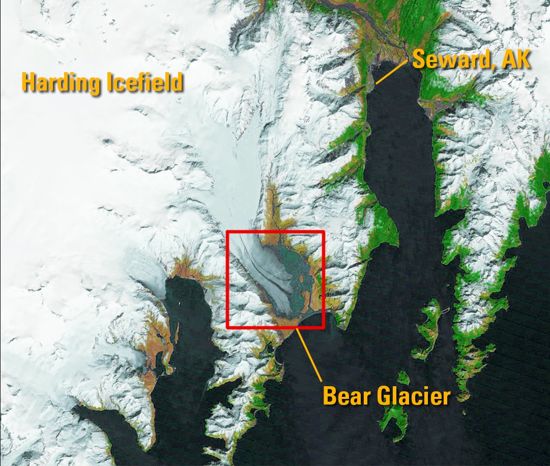
| 18:17, 14. Feb. 2020 | Bear Glacier landsat 110613.jpg (Datei) |  |
357 KB | Satellitenbild des Bear-Gletscher am 11. Juni 2013 ==Lizenzhinweis== {| style="border:1px solid #8888aa; background-color:#f7f8ff;padding:5px;font-size:95%;" | Quelle: USGS (landsat): [https://remotesensing.usgs.gov/gallery/image_collections?img:348:8… | 1 |
| 18:15, 14. Feb. 2020 | Bear Glacier landsat 020601.jpg (Datei) |  |
343 KB | Satelitenbild des Bear-Gletscher am 02. Juni 2001 ==Lizenzhinweis== {| style="border:1px solid #8888aa; background-color:#f7f8ff;padding:5px;font-size:95%;" | Quelle: USGS (landsat): [https://remotesensing.usgs.gov/gallery/image_collections?img:348:8… | 1 |
| 18:13, 14. Feb. 2020 | Bear Glacier landsat 160589.jpg (Datei) |  |
411 KB | Satelitenbild des Bear-Gletscher am 16. Mai 1989 ==Lizenzhinweis== {| style="border:1px solid #8888aa; background-color:#f7f8ff;padding:5px;font-size:95%;" | Quelle: USGS (landsat): [https://remotesensing.usgs.gov/gallery/image_collections?img:348:8 B… | 1 |
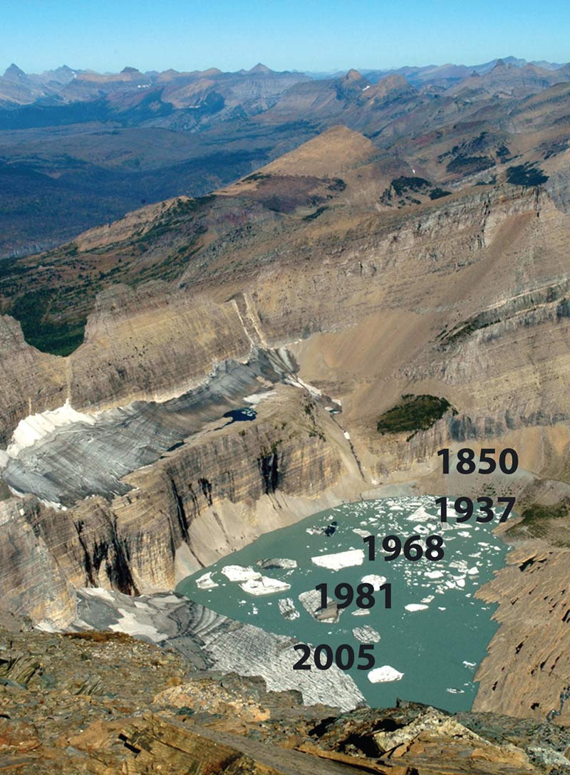
| 18:05, 14. Feb. 2020 | Grinnell glacier1850 1937 1968 1981 2005.jpg (Datei) |  |
158 KB | Rückgang des Grinnell Glacier (Montana) Jahre 1850, 1937, 1968, 1981, 2005 ==Lizenzhinweis== {| style="border:1px solid #8888aa; background-color:#f7f8ff;padding:5px;font-size:95%;" | Quelle: Lisa McKeon, USGS: [https://www.usgs.gov/media/images/grin… | 1 |
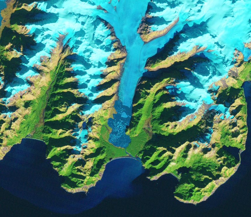
| 16:59, 14. Feb. 2020 | Kaskawulsh-glacier 04 07 16.jpg (Datei) |  |
112 KB | Kaskawulsh-Gletscher (westliches Kanada) 4. Juli 2016 ==Lizenzhinweis== {| style="border:1px solid #8888aa; background-color:#f7f8ff;padding:5px;font-size:95%;" | Quelle: USGS: [https://www.usgs.gov/media/images/kaskawulsh-glacier-canada Kaskawulsh Gl… | 1 |
| 16:56, 14. Feb. 2020 | Kaskawulsh-glacier 03 08 15.jpg (Datei) |  |
108 KB | Kaskawulsh-Gletscher (westliches Kanada) 3. August 2015 ==Lizenzhinweis== {| style="border:1px solid #8888aa; background-color:#f7f8ff;padding:5px;font-size:95%;" | Quelle: USGS: [https://www.usgs.gov/media/images/kaskawulsh-glacier-canada Kaskawulsh… | 1 |
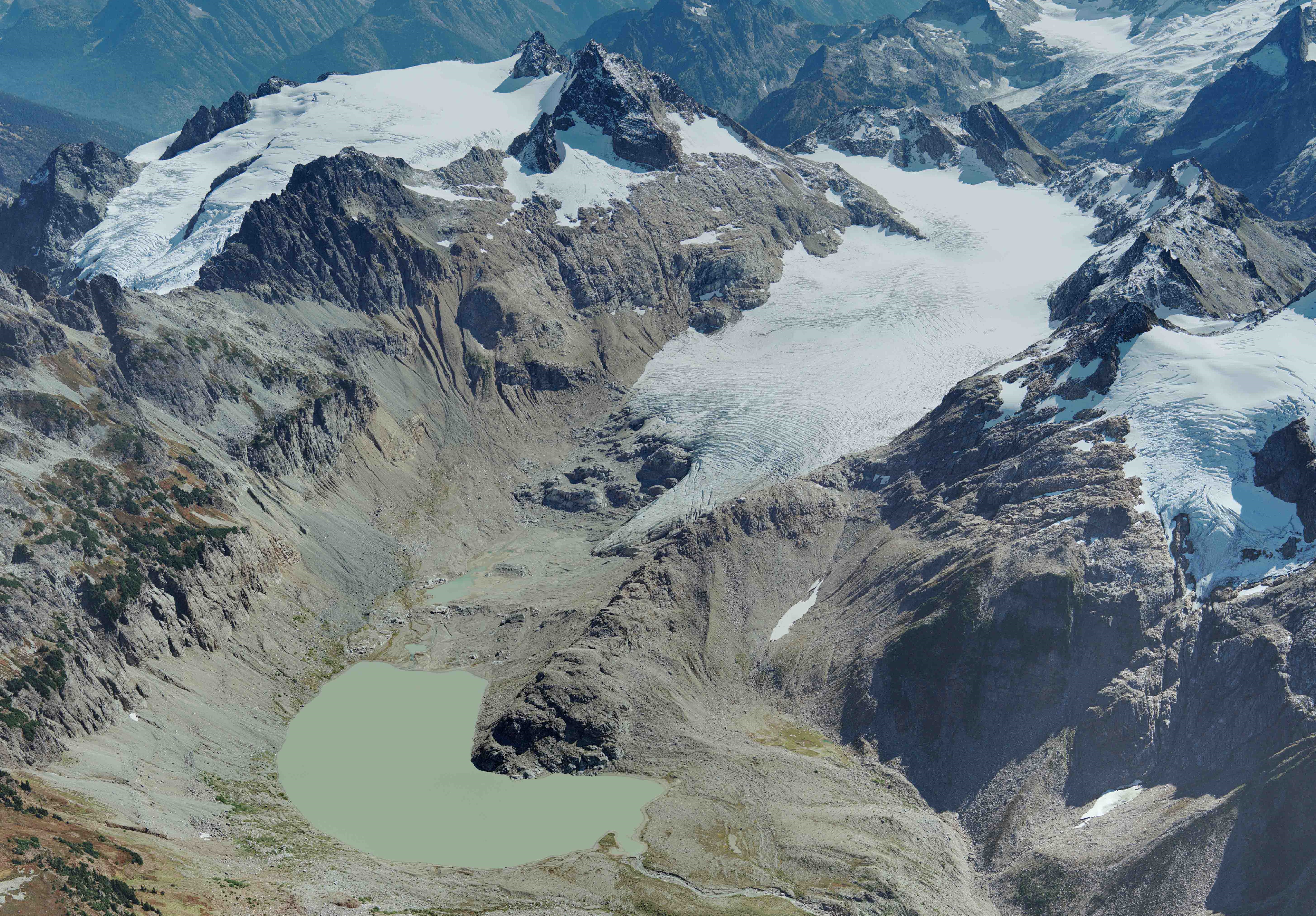
| 16:01, 14. Feb. 2020 | Klinakliniglacier2018.jpg (Datei) |  |
585 KB | Klinaklini-Gletscher in British Columbia Spätsommer 2018 ==Lizenzhinweis== {| style="border:1px solid #8888aa; background-color:#f7f8ff;padding:5px;font-size:95%;" | Quelle: NASA Landsat Science: New Research Shows Significant Decline of Glaciers in W… | 1 |
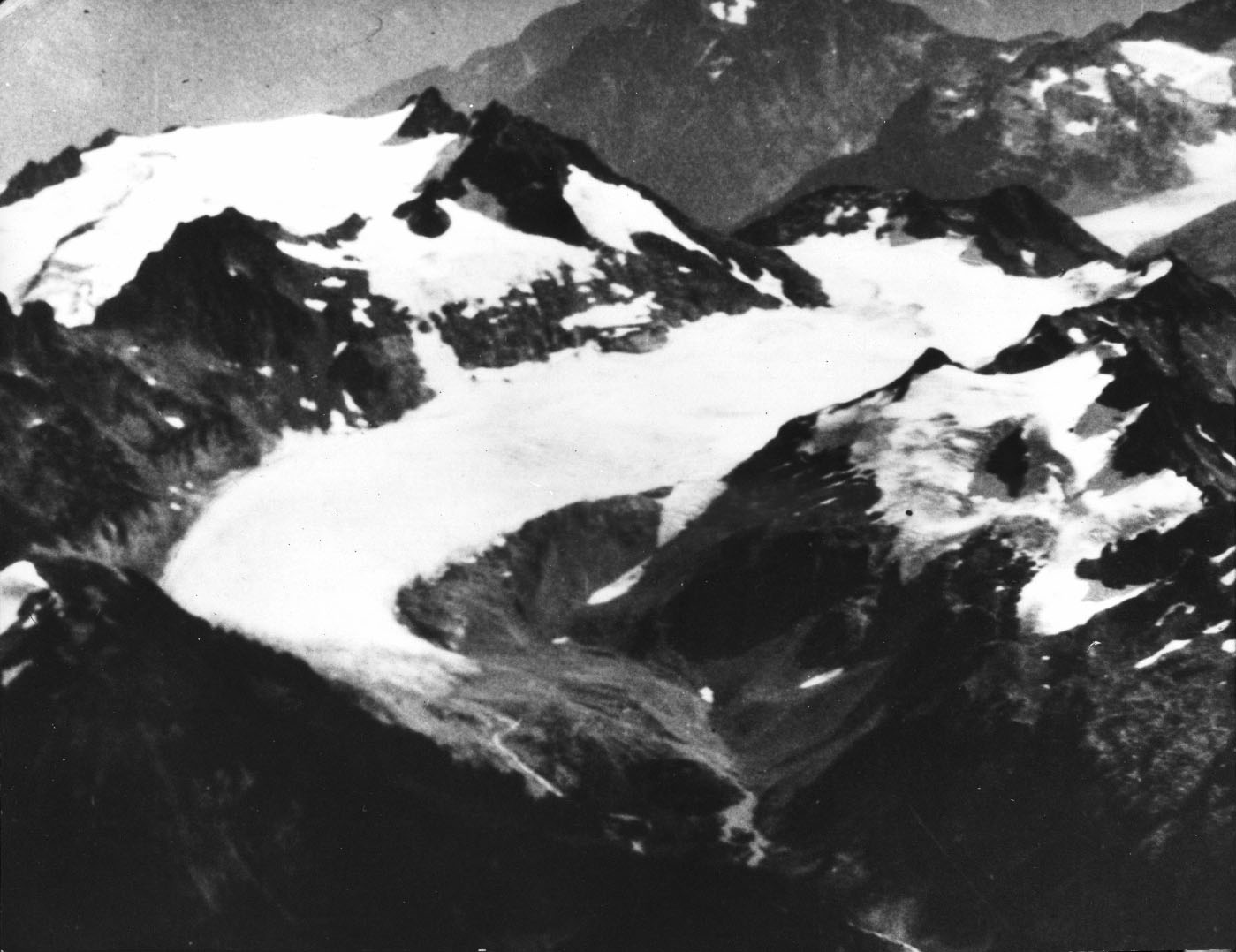
| 15:54, 14. Feb. 2020 | Klinakliniglacier2000.jpg (Datei) |  |
550 KB | Klinaklini-Gletscher in British Columbia Spätsommer 2000 ==Lizenzhinweis== {| style="border:1px solid #8888aa; background-color:#f7f8ff;padding:5px;font-size:95%;" | Quelle: NASA Landsat Science: New Research Shows Significant Decline of Glaciers in W… | 1 |
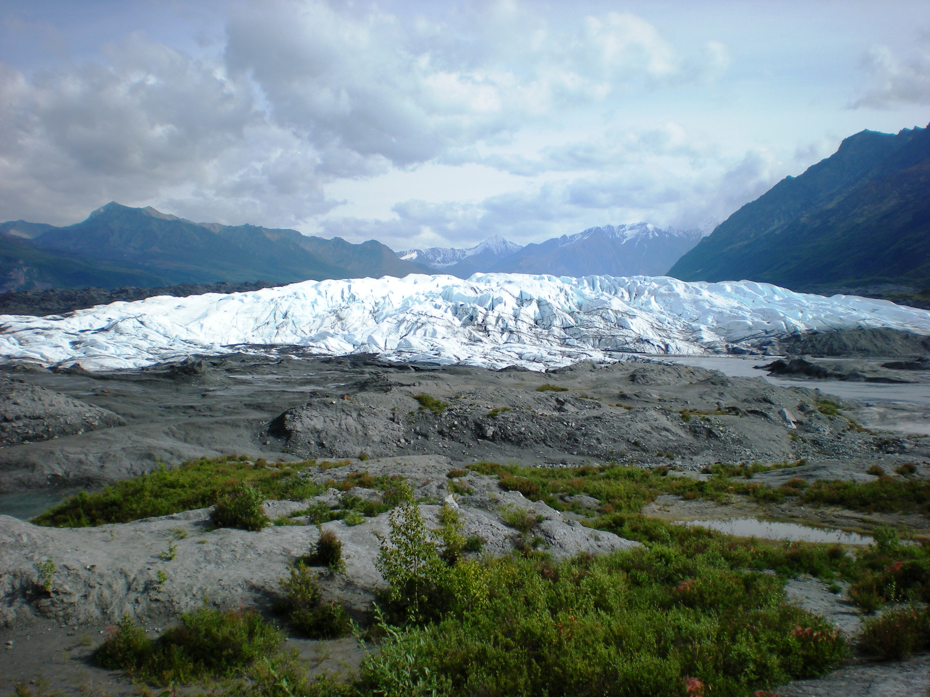
| 15:46, 14. Feb. 2020 | Matanuska Glacier 18 08 2008.JPG (Datei) |  |
4,7 MB | Matanuska-Gletscher 18. August 2008 ==Lizenzhinweis== {| style="border:1px solid #8888aa; background-color:#f7f8ff;padding:5px;font-size:95%;" | Quelle: Dean Gesch, USGS: [https://www.usgs.gov/media/images/matanuska-glacier Matanuska Glacier]<br> Lizen… | 1 |
| 15:42, 14. Feb. 2020 | Muir Riggs Glacier 1941.jpg (Datei) |  |
1,25 MB | Muir-Gletscher (rechts)und Riggs-Gletscher 13. August 1941 ==Lizenzhinweis== {| style="border:1px solid #8888aa; background-color:#f7f8ff;padding:5px;font-size:95%;" | Quelle: USGS: [https://www.usgs.gov/media/images/muir-and-riggs-glaciers-muir-inlet-… | 1 |
| 15:36, 14. Feb. 2020 | Muir Glacier 1950.jpg (Datei) |  |
223 KB | Muir-Gletscher 04. August 1950 ==Lizenzhinweis== {| style="border:1px solid #8888aa; background-color:#f7f8ff;padding:5px;font-size:95%;" | Quelle: USGS: [https://www.usgs.gov/media/images/muir-glacier-glacier-bay-national-monument-1950 Muir Glacier… | 1 |
| 15:32, 14. Feb. 2020 | Muir Glacier 1980.jpg (Datei) |  |
1,92 MB | Muir-Gletscher 01. August 1980 ==Lizenzhinweis== {| style="border:1px solid #8888aa; background-color:#f7f8ff;padding:5px;font-size:95%;" | Quelle: Bruce Molnia: [https://www.usgs.gov/media/images/muir-glacier-and-muir-inlet-1980 Muir Glacier and Muir… | 1 |
| 15:22, 14. Feb. 2020 | Muir Glacier 2003.jpg (Datei) |  |
1,49 MB | Muir-Gletscher 01. September 2003 ==Lizenzhinweis== {| style="border:1px solid #8888aa; background-color:#f7f8ff;padding:5px;font-size:95%;" | Quelle: Bruce Molnia, USGS: [https://www.usgs.gov/media/images/muir-glacier-and-muir-inlet-1980 Muir Glacier… | 1 |
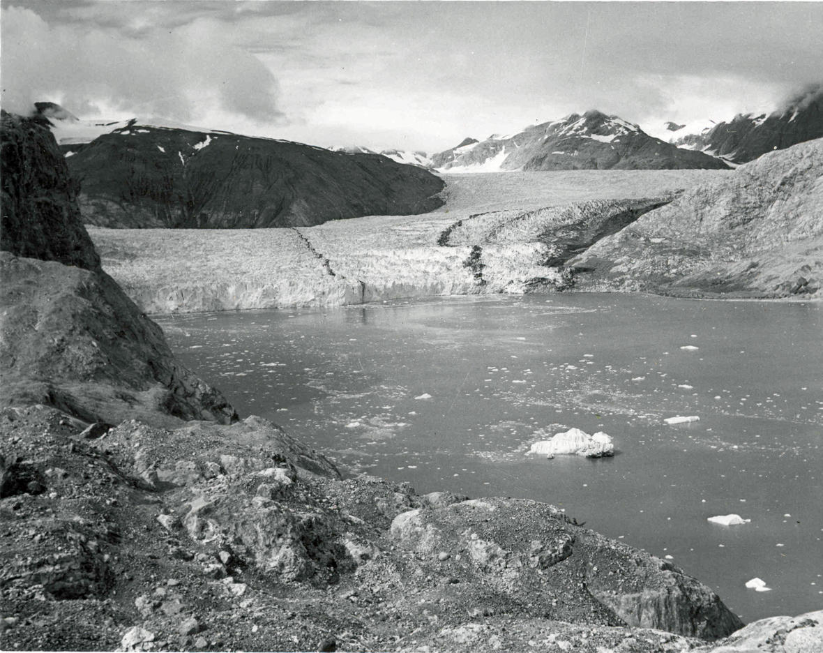
| 15:15, 14. Feb. 2020 | Nellie Juan Glacier Alaska.jpg (Datei) |  |
261 KB | Nellie-Juan-Gletscher Foto ungefähr 2018 aufgenommen ==Lizenzhinweis== {| style="border:1px solid #8888aa; background-color:#f7f8ff;padding:5px;font-size:95%;" | Quelle: Jeremy Littell: [https://www.usgs.gov/media/images/view-wolverine-glacier-helic… | 1 |
| 14:27, 14. Feb. 2020 | Taku trange summer 2019.jpg (Datei) |  |
126 KB | Eisfeld am Taku-Gletscher Sommer 2019 ==Lizenzhinweis== {| style="border:1px solid #8888aa; background-color:#f7f8ff;padding:5px;font-size:95%;" | Quelle: Christopher McNeil, USGS: [https://www.usgs.gov/media/images/taku-range-juneau-icefield-alaska Ta… | 1 |
| 14:23, 14. Feb. 2020 | Layers of ice Hayden Glacier 2004.JPG (Datei) |  |
432 KB | Eissischten am Hayden-Gletscher ausgenommen im Jahr 2004 ==Lizenzhinweis== {| style="border:1px solid #8888aa; background-color:#f7f8ff;padding:5px;font-size:95%;" | Quelle: Damon Runberg, USGS: [https://www.usgs.gov/media/images/layers-ice-hayden-glac… | 1 |
| 14:04, 14. Feb. 2020 | Glacier national park MT 19June2010.JPG (Datei) |  |
444 KB | Gletscher im Glacier National Park im US-Bundesstaat Montana aufgenommen am 19. Juni 2010 ==Lizenzhinweis== {| style="border:1px solid #8888aa; background-color:#f7f8ff;padding:5px;font-size:95%;" | Quelle: Connie, USGS: [https://www.usgs.gov/media/ima… | 1 |