Verwaiste Dateien
Aus Klimawandel
Bitte beachten Sie, dass andere Webseiten eine Datei mit einer direkten URL verlinken können. Sie könnte daher hier aufgelistet sein, obwohl sie in aktiver Verwendung ist.
Unten werden bis zu 100 Ergebnisse im Bereich 101 bis 200 angezeigt.
-
 Groenland Eem.jpg 341 × 439; 93 KB
-
 Europa klimazonen.jpg 458 × 304; 81 KB
-
 Wald Schorfheide.jpg 700 × 525; 86 KB
-
 Europa agrarklimazonen 2100.jpg 716 × 349; 147 KB
-
 Kanada temp 2000.jpg 464 × 302; 64 KB
-
 USA temp 2000.jpg 509 × 200; 58 KB
-
 Meeresspiegel global 1993-2011.jpg 565 × 358; 43 KB
-
 2-Grad-Ziel.jpg 529 × 418; 72 KB
-
 Emissionspfade.jpg 617 × 441; 131 KB
-
 CO2 Emissionen historisch.jpg 567 × 375; 24 KB
-
 Köln Rheinufer Hochwasser.jpg 589 × 599; 70 KB
-
 Hochwasserrisiko Kontinente.jpg 544 × 663; 71 KB
-
 Pdoindex.png 987 × 526; 31 KB
-
 Massenbilanz Antarktis1992-2010.jpg 523 × 374; 89 KB
-
 ENSO Index1950-2010.jpg 716 × 223; 40 KB
-
 CIMG0399.JPG 1.600 × 1.200; 1,15 MB
-
 Hochwasserjährlichkeit-Europa.jpg 591 × 311; 77 KB
-
 CCA3.0.jpg 94 × 35; 2 KB
-
 Heat content700m2000myr.png 566 × 380; 27 KB
-
 Brikdalsbreen sm.jpg 448 × 290; 100 KB
-
 Spitzbergen Sommer Temp.jpg 439 × 296; 56 KB
-
 Prec rcp85 geogr Sommer Winter 2071-2100.jpg 650 × 800; 262 KB
-
 CO2 budget 2002-2011.jpg 661 × 622; 62 KB
-
 Afrika RCP85 Temp.jpg 410 × 260; 74 KB
-
 Amazon drought 2005.jpg 350 × 353; 41 KB
-
 Rotmoosferner Wasserfallferner.jpg 840 × 432; 94 KB
-
 Änderungen der Massenbilanz pro Jahr in Wasseräquivalenten.jpg 1.152 × 667; 153 KB
-
 RekTemperaturen verschiedeneAntriebe.jpg 1.280 × 1.132; 556 KB
-
 Heterogene Klimarekonstruktion NH.png 263 × 516; 30 KB
-
 Phytoplankton Ceratium.jpg 200 × 200; 38 KB
-
 Algenblüte Tag 26 EIFEX.jpg 600 × 475; 0 Bytes
-
 ENSO-Index1950-2014.jpg 686 × 240; 91 KB
-
 Temp Mittelasien 1979-2011.jpg 575 × 293; 59 KB
-
 Chacaltaya.JPG 3.456 × 2.592; 137 KB
-
 Temp Sibirien 1951 2005.jpg 518 × 290; 47 KB
-
Holzige Biomasse Plantage.jpg Datei fehlt
-
Bewirtschafteter Wald.jpg Datei fehlt
-
Natürlicher Wald.jpg Datei fehlt
-
Änderung natürliche Vegetation 800-1992.jpg Datei fehlt
-
Snow Masking effekt.jpg Datei fehlt
-
Aufforstungsregionen.jpg Datei fehlt
-
 IPCC AR5 WGI cover.jpg 300 × 406; 251 KB
-
Biomasse Gras.JPG Datei fehlt
-
 Australia heatwave 2013.jpg 720 × 511; 216 KB
-
 O-Afrika Niederschläge2100.jpg 343 × 414; 64 KB
-
 Kalifornien Dürre2013 14.jpg 342 × 361; 116 KB
-
 Arctic amplification.png 720 × 360; 186 KB
-
 Zonale Erwärmung2001-2010.jpg 487 × 331; 15 KB
-
 CO2-Emissionen staaten.jpg 727 × 451; 148 KB
-
 SL 7m NASA.jpg 2.048 × 1.024; 361 KB
-
 N2O Konzentration.jpg 476 × 234; 37 KB
-
 Meeresspiegel 2100 tabelle.jpg 811 × 253; 40 KB
-
 RCP temp land sea 2100.jpg 822 × 304; 96 KB
-
 Meeresspiegelanstie2100 szenarien.jpg 491 × 118; 22 KB
-
 Meeresspiegel2100 RCP.jpg 553 × 131; 65 KB
-
 Antarktisches Meereis Jahreszeiten.jpg 473 × 375; 23 KB
-
 Antarctic seaice winter-summer.jpg 722 × 349; 31 KB
-
 Afrika Temp diff2 RCP8.5.jpg 549 × 548; 180 KB
-
 Langtang range Nepal.JPG 799 × 214; 28 KB
-
 Ocean heat content1955-2015.png 566 × 380; 45 KB
-
 Ozeanerwärmung 0-700-2000.jpg 734 × 327; 32 KB
-
 Linreg.png 960 × 720; 9 KB
-
 Solarzyklen1995-2015.gif 1.024 × 768; 207 KB
-
 ENSO SST Okt2015.jpg 541 × 322; 49 KB
-
 Temp1980-2012.jpg 623 × 566; 127 KB
-
 Cop21-header-clisap.png 400 × 226; 96 KB
-
 CO2 budget 2005-2014.jpg 731 × 687; 71 KB
-
 Temp NASA 2015.jpg 747 × 437; 57 KB
-
 2015 winter summer.jpg 800 × 282; 248 KB
-
 SST global 2070 2099 RCP8.5 Jahresmittel.jpg 880 × 576; 278 KB
-
 Temp D 1880-2014.jpg 552 × 389; 48 KB
-
 Meereisausdehnung arktis.jpg 745 × 449; 109 KB
-
 Meeresspiegel global 2100 zu 1990.jpg 880 × 576; 287 KB
-
 CH4 1987-2017.jpg 660 × 397; 94 KB
-
 TR in Tropennacht DiffII Nordd Sommer .png 1.024 × 688; 60 KB
-
 CO2-Emissionen1990-2014.jpg 775 × 462; 105 KB
-
 Verd in Verdunstung Nordamerika rcp85 di.png 1.024 × 688; 61 KB
-
 Sealevelrise NOAA.jpg 724 × 521; 49 KB
-
 Australien temp1910-2011.jpg 545 × 314; 89 KB
-
 SST Atlantik Pazifik.jpg 449 × 518; 112 KB
-
 World-ocean-salt2005sm.jpg 580 × 405; 66 KB
-
 Eisberge vor Ilulissat.jpg 1.200 × 800; 990 KB
-
 Treibeis bei Kulusuk.jpg 1.200 × 800; 1.010 KB
-
 Gletscherfront Sermilik Icefjord.jpg 1.200 × 800; 977 KB
-
 Ozeanströmungen sm.jpg 600 × 314; 31 KB
-
 Pine-I Twaites ice flux.jpg 559 × 705; 88 KB
-
 Global temp 1880 2017.jpg 731 × 419; 44 KB
-
 Ocean heat content1955-2018.jpg 683 × 447; 48 KB
-
 Precipitation-global1900-2016.png 928 × 591; 23 KB
-
 SLR Topex Poseidon Jason1993-2018.jpg 513 × 397; 36 KB
-
 Global-Methane-Budget.png 1.240 × 678; 126 KB
-
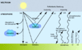 Strahlungshaushalt.gif 685 × 414; 55 KB
-
 Bayern eistage jahr 1881-2019.jpg 840 × 779; 72 KB
-
 Bayern heiße tage jahr 1881-2019.jpg 840 × 781; 62 KB
-
 Arctic ice-extent Sept1979-2019.png 1.024 × 791; 209 KB
-
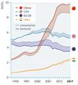 CO2 consumption territorial.jpg 553 × 603; 38 KB
-
 Treibhausgase0-aktuell.jpg 546 × 447; 87 KB
-
 Tropical storm tracks N-Atlantic2017.png 4.096 × 1.933; 875 KB
-
 Jackson Glacier 1941.jpg 1.500 × 971; 213 KB
-
 Glacier national park MT 19June2010.JPG 1.280 × 960; 444 KB


