Datei:Land-cover classes FAO.jpg
Aus Klimawandel

Größe dieser Vorschau: 800 × 553 Pixel. Weitere Auflösung: 2.244 × 1.550 Pixel.
Originaldatei (2.244 × 1.550 Pixel, Dateigröße: 395 KB, MIME-Typ: image/jpeg)
Beschreibung
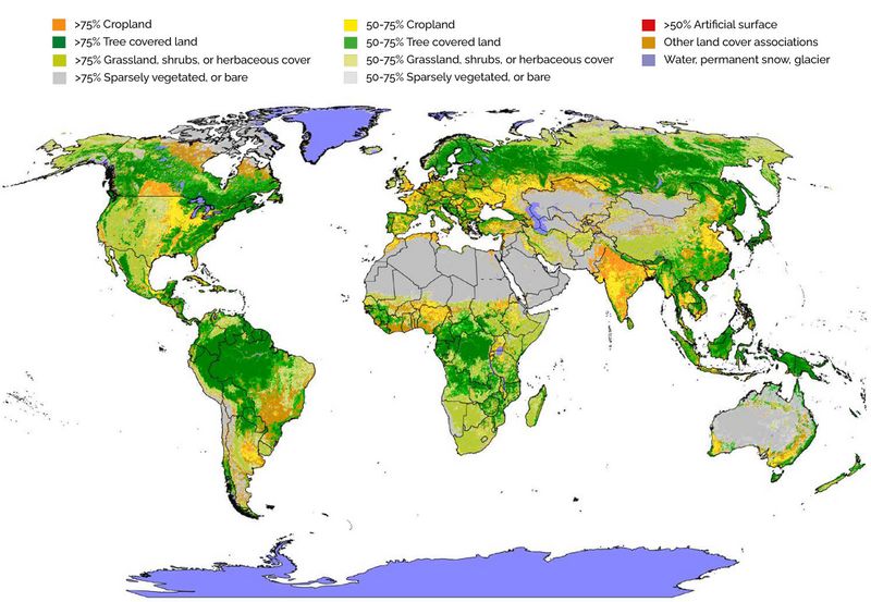
Landbdedeckung nach FAO-Klassifizierung
Lizenzhinweis
| Quelle: : FAO (2021): The State of the World’s Land and Water Resources for Food and Agriculture – Systems at breaking point. Synthesis report, https://doi.org/10.4060/cb7654en Lizenz: CC BY-NC-SA https://creativecommons.org/licenses/by-nc-sa/3.0/igo/legalcode |
Dateiversionen
Klicken Sie auf einen Zeitpunkt, um diese Version zu laden.
| Version vom | Vorschaubild | Maße | Benutzer | Kommentar | |
|---|---|---|---|---|---|
| aktuell | 18:49, 19. Dez. 2023 | | 2.244 × 1.550 (395 KB) | Dieter Kasang (Diskussion | Beiträge) | == Beschreibung == Vegetationsbedeckung == Lizenzhinweis == {| style="border:1px solid #8888aa; background-color:#f7f8ff;padding:5px;font-size:95%;" | Quelle: Li, Y., Z.-L. Li, H. Wu et al. (2023): [https://doi.org/10.1038/s41467-023-35799-4 Biophysical impacts of earth greening can substantially mitigate regional land surface temperature warming]. Nat Commun 14, 121, Suppl.<br> Lizenz: [https://creativecommons.org/licenses/by/4.0/ CC BY] |} |
Sie können diese Datei nicht überschreiben.
Dateiverwendung
Die folgende Seite verwendet diese Datei: